WatershedX
A National-Scale Hydrologic Intelligence System for SEEA-Water Aligned Governance
Water is no longer only an environmental concern—it is an economic, governance, and national security issue.
In the Philippines and across many regions, increasing pressure from population growth, land use change, and climate variability is driving a critical condition:
Water bankruptcy — where water demand exceeds sustainable supply and management systems fail to respond effectively.
Despite significant investments in studies, data collection, and planning, river basin management remains:
- •fragmented across institutions
- •reactive rather than predictive
- •disconnected from national accounting systems
This results in inefficient allocation, delayed intervention, and limited ability to measure and manage water resources as a national asset.
The Missing Link: From Data to Accounting
Water governance today faces a fundamental gap:
We have data, but we do not have structured systems that connect hydrology to accounting and decision-making.
This is where WatershedX operates.
What is WatershedX?
WatershedX is a computational hydrologic intelligence system that transforms river basins into structured, analyzable, and decision-ready platforms.
- system-level understanding of basin behavior
- continuous monitoring of hydrologic processes
- integration of environmental data with economic accounting
- support for national, regional, and local decision-making
Water is no longer only an environmental concern—it is an economic, governance, and national security issue.
In the Philippines and across many regions, increasing pressure from population growth, land use change, and climate variability is driving a critical condition:
- •water stocks (availability)
- •water flows (abstraction, use, return)
- •economic use of water across sectors
However, a major implementation challenge remains:
How do we spatially and physically account for water across real river basins?
WatershedX bridges this gap
WatershedX operationalizes SEEA-Water by:
Structuring Water Stocks
- •identifying storage zones (uplands, aquifers, floodplains, marsh systems)
- •mapping natural and engineered storage elements
Tracking Water Flows
- •modeling upstream–downstream movement
- •quantifying contributions from tributaries
- •tracing abstraction and return flows spatially
Linking Physical and Economic Use
- •associating water flows with sectors (agriculture, domestic, industry)
- •enabling attribution of water use at basin and sub-basin levels
Enabling Spatial Accounting
- •moving beyond tabular accounts
- •embedding SEEA-Water within a geospatial, basin-based framewor
Enabling Spatial Accounting
- •moving beyond tabular accounts
- •embedding SEEA-Water within a geospatial, basin-based framewor
WatershedX transforms SEEA-Water from a reporting framework into a computational, spatial accounting system
Water is no longer only an environmental concern—it is an economic, governance, and national security issue.
Traditional watershed approaches rely on:
- basin boundaries
- thematic maps
- isolated models
WatershedX advances this into:
continuous, system-level intelligence aligned with accounting and governance
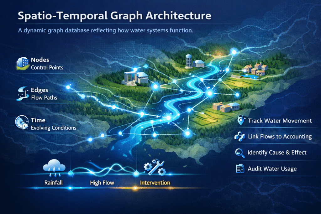
Spatio-Temporal Graph Architecture
WatershedX is built on a spatio-temporal graph database, reflecting how water systems actually function.
Core structure:
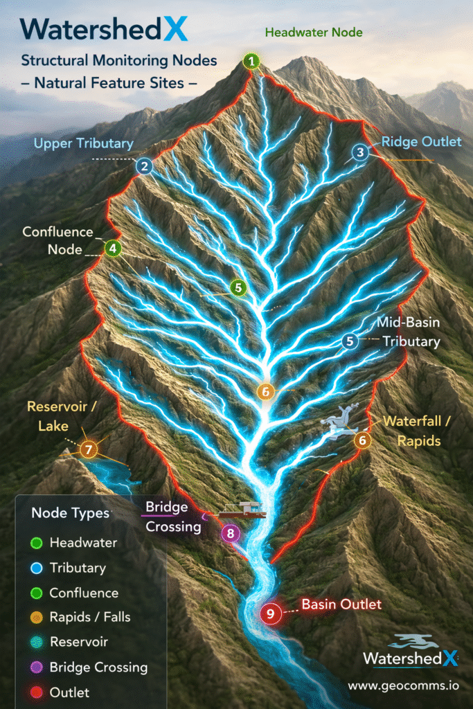
- Nodes → control points (confluences, storage zones, infrastructure)
- Edges → flow paths (rivers, channels, connections)
- Time → evolving conditions (rainfall, flow, interventions)
Why this matters for SEEA-Water
This architecture allows:
- •tracing water movement across space and time
- •linking physical flows to accounting units
- •identifying cause–effect relationships across the basin
- •supporting auditability of water use and allocation
Multi-Basin and National Integration
River systems are interconnected and often transcend administrative boundaries.
WatershedX enables: multi-basin analysis as a unified hydrologic system
WatershedX is built on a spatio-temporal graph database, reflecting how water systems actually function.
- national water resource accounting
- inter-LGU coordination
- basin-to-basin interaction analysis
- regional planning and investment decisions
Supporting Governance Across Levels
- For DENR and National Agencies:
- implementation of SEEA-Water at basin scale
- integrated monitoring of water stocks and flows
- support for regulatory enforcement and allocation policies
- alignment with national environmental accounting initiatives
- For LGUs:
- localized water balance understanding
- identification of water deficits and risks
- integration of watershed intelligence into CLUP and DRRM plans
- support for evidence-based decision-making
- For UN and Development Partners:
- standardized, scalable accounting systems
- measurable indicators for sustainability programs
- integration of environmental and economic datasets
- transparent and auditable frameworks
Addressing Water Bankruptcy Through System Intelligence
Water bankruptcy emerges when:
- water use is not linked to actual basin capacity
- upstream and downstream dynamics are not understood
- decision-making is fragmented
WatershedX addresses this by enabling:
- Basin-Level Water Balance
Understanding supply, demand, and flows within a unified system
- Attribution of Use
Linking water abstraction and return flows to sectors and locations
- Early Warning and Risk Detection
Identifying imbalances before they become crises
- Decision Support
Guiding:
- •allocation policies
- •infrastructure investments
- •conservation strategies
Toward an Enterprise Hydrologic Accounting System
WatershedX represents a new class of Enterprise GIS:
|
Traditional GIS
|
WatershedX
|
|---|---|
|
Map-centric
|
System-centric
|
|
Static data
|
Dynamic, time-aware
|
|
System-centric
|
Integrated accounting
|
|
Visual outputs
|
Decision intelligence
|
Building Institutional Capability
WatershedX enables governments and institutions to develop:
a unified hydrologic data infrastructure
a spatially grounded SEEA-Water accounting system
cross-agency coordination mechanisms
long-term sustainability in water governance
Conclusion
As water challenges intensify, the key question is no longer:
“Do we have enough data?”
But:
“Do we have the system to account for, understand, and manage water as a national asset?”
WatershedX provides that system.
It enables the transition from fragmented, reactive approaches toward:
integrated, spatially grounded, and accounting-driven water governance
WatershedX is not just a tool.
It is: a hydrologic intelligence and SEEA-Water accounting system for sustainable national development