Terrain Diagnostics
Terrain X
Watershed Intelligence
Diagnosing
watershed failure before it happens
TerrainX™ is a terrain-first diagnostic system for understanding how watersheds truly behave.
It operates independent of rainfall assumptions, historical flood records, or isolated engineering projects.
TerrainX answers a foundational question most studies skip:
Is the land itself still capable of functioning as a watershed?
If terrain structure is compromised, no amount of modeling or mitigation can prevent failure.
Case Studies
Real diagnostic assessments from terrain-driven infrastructure failures
Upland Mountain Road (Active Landslide Zone)
Active landslide / slope collapse
Active landslide / slope collapse evident beneath roadway. This is not a sudden collapse. This is a geometry-driven failure unfolding over time.
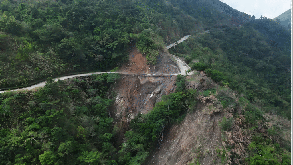
- GOOD
- BAD
- UGLY (TRIGGERS)
Essential Connectivity
Road alignment provides essential connectivity. Surrounding catchment still largely vegetated. No dense urban loading on the slope.
Terrain Conflict
Road cut slices across a steep, continuous hillslope. Exposed material shows low-cohesion, layered soil/rock. Road surface and side drains accelerate water toward the cut.
Geometry-Driven Failure
If sustained rainfall occurs → subsurface saturation builds beneath the road. Why: intercepted uphill flow + cut exposure exceed slope shear resistance. Result: progressive undercutting → slab failure → road edge loss.
OVERALL STATE
Structurally present, terrain-conflicted, failure recurring
INTERVENTION (TERRAIN-FIRST)
Intercept and slow water upslope before it reaches the cut. Ensure water crosses the road safely, not along it. Treat the cut slope as a living hydrologic face, not a static wall. Preserve ridge shoulders and upper slopes as control zones, not drainage shortcuts.
BOTTOM LINE
“The road did not fail because the slope was weak. It failed because water was delivered to the slope too efficiently.”
Ridge-Spine Mountain Road (Bukidnon-type terrain)
Before-failure geometry, high latent risk
Before-failure geometry, high latent risk. This is a delayed-failure setup. The road is safe — until it suddenly isn’t.
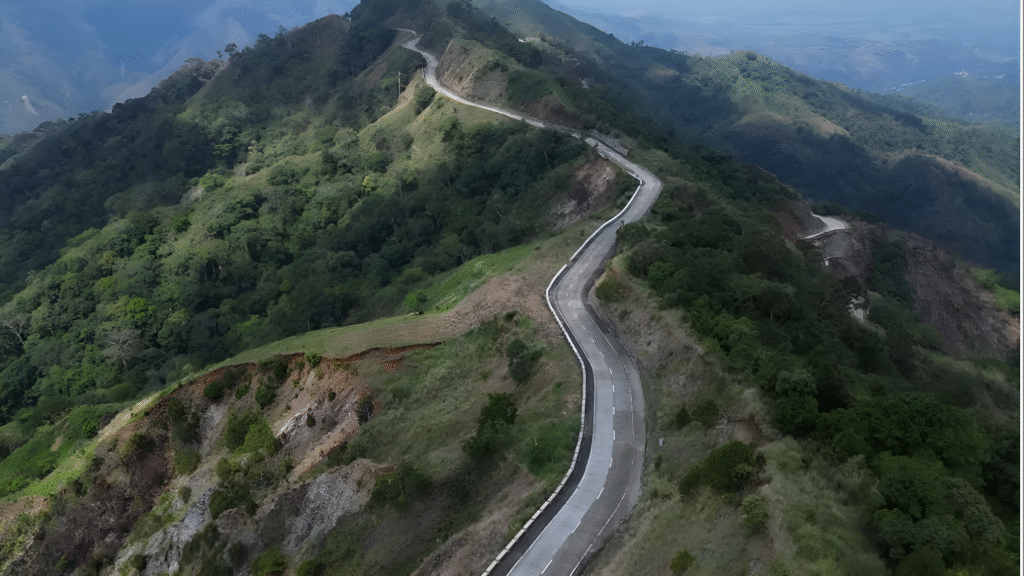
- GOOD
- BAD
- UGLY (TRIGGERS)
Ridge Alignment
Road largely follows the ridge spine (better than mid-slope cuts). Surrounding terrain remains mostly vegetated. No heavy urban or industrial surcharge on the slope.
Critical Exposure
Road alignment rides the ridge crest and shoulder continuously. Multiple segments sit directly above steep drop-offs. Concrete surface creates a fast, uninterrupted runoff conveyor.
Delayed Failure Setup
If prolonged rainfall occurs → water accelerates along the road. Why: ridge-top flow capture + limited lateral release exceed slope tolerance. Result: shoulder erosion → edge cracking → downslope mass loss.
OVERALL STATE
Visually impressive, structurally exposed, terrain-critical
INTERVENTION (TERRAIN-FIRST)
Interrupt runoff along the road before it gains momentum. Force water to exit the road early and often, not travel long distances. Treat ridge shoulders as control zones, never as drainage paths. Preserve vegetation at ridge edges as structural terrain armor. (No redesign. No retrofitting details. Behavior correction only.)
BOTTOM LINE
“Ridge roads fail quietly — not from weight, but from unmanaged water speed.”
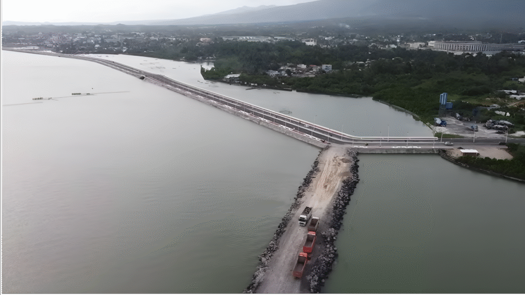
Davao Coastal Road
Major coastal transport infrastructure
Major coastal transport infrastructure (pre-failure evaluation). This is not a mountain road problem. This is a coastal–river–urban terrain interaction problem. This is not immediate failure. This is slow-burn system stress.
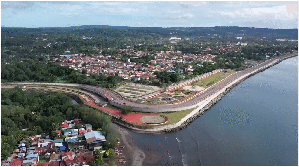
- GOOD
- BAD
- UGLY (TRIGGERS)
Smart Structure
Elevated and bridged sections allow tidal and river exchange. Alignment avoids direct mid-slope cutting (good structural choice). Breakwater and revetment reduce direct wave attack.
System Alteration
Road acts as a hard coastal boundary, altering natural water movement. River mouths and drainage outlets now operate under new backwater conditions. Urban runoff is concentrated and redirected, not dispersed.
Hydraulic Trapping
If intense rainfall coincides with high tide → inland water backs up. Why: coastal confinement + limited discharge windows exceed drainage capacity. Result: urban flooding, sediment trapping, long-term scouring at outlets.
OVERALL STATE
Structurally strong, terrain-reconfigured, system-sensitive
INTERVENTION (TERRAIN-FIRST)
Ensure frequent and generous water crossings (river, creek, drainage). Prevent the road from acting as a continuous coastal dam. Monitor and manage sediment behavior, not just wave energy. Treat coastal roads as part of the watershed system, not separate from it. (No redesign critique. No political framing. System behavior only.)
BOTTOM LINE
“Coastal roads do not usually fail by collapse. They fail by changing how water behaves inland.”
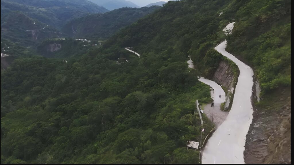
High-Relief Upland / Ridge-Valley Agricultural Terrain
Serpentine concrete road, pre-failure geometry visible
Access achieved, terrain stability compromised. This road is functional today but structurally negotiating against terrain logic. This is not one big landslide risk. This is many small, inevitable failures accumulating over time.
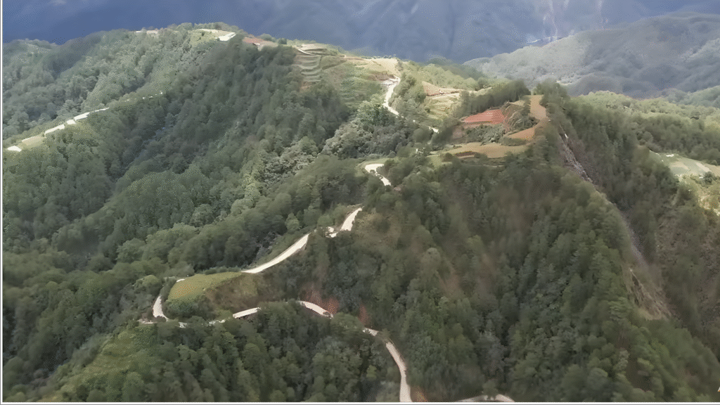
- GOOD
- BAD
- UGLY (TRIGGERS)
Gradient Management
Alignment uses switchbacks to manage gradient (better than straight cuts). Large portions of the surrounding slope remain vegetated. No dense urban surcharge directly loading the slope.
Terrain Interruption
Repeated tight S-curves stacked on a continuous slope. Road repeatedly cuts across natural drainage and micro-catchments. Cut-and-fill pattern creates alternating over-steepened faces. The road keeps interrupting how the mountain wants to drain.
Cumulative Failure Pattern
If prolonged rainfall occurs → water concentrates at curve exits. Why: runoff accelerates along concrete, then dumps into cut slopes and fills. Result: slope saturation → localized slips → progressive road damage.
OVERALL STATE
Access achieved, terrain stability compromised
INTERVENTION (TERRAIN-FIRST)
Prevent water from running long distances along the road. Force water to exit safely before curves, not after them. Treat each cut slope as a hydrologic system, not a static face. Preserve vegetation buffers above and below the road as load reducers. (No redesign critique. Behavior correction only.)
BOTTOM LINE
“This road will not fail all at once. It will fail segment by segment, exactly where water is forced to decide.”
New Coastal Road with Rock Armor (Boulders)
Seaward side protection
New coastal road with temporary/permanent rock armor (boulders) on the seaward side.
Question: Are the boulders wrong?
SHORT ANSWER: The boulders are not ‘wrong’ structurally — but they are incomplete terrain engineering if left as-is. They solve wave impact, but they do not fully solve water behavior.
- GOOD
- BAD
- UGLY (TRIGGERS)
Wave Protection
Rock armor absorbs direct wave energy (correct intent). Elevated road deck reduces overtopping risk. Linear alignment minimizes head-on wave attack.
Incomplete Engineering
Boulders form a hard, continuous barrier with limited permeability. Water is reflected and deflected, not dissipated and exchanged. Fine sediments can be trapped or scoured at transitions (ends, gaps, outlets).
Risk Migration
If strong waves coincide with river discharge or heavy rain → backwater + turbulence forms. Why: rigid armor blocks lateral exchange while outlets concentrate flow. Result: scour at toe and ends, undermining of armor, inland flooding pressure during high tide events.
OVERALL STATE
Structurally protected, hydraulically sensitive
INTERVENTION (TERRAIN-FIRST)
Ensure rock armor has designed permeability, not just mass. Provide frequent, generous water exchange paths (creeks, drains, tidal flow). Treat armor transitions (start/end points) as high-risk zones. Monitor sediment behavior, not just wave height.
BOTTOM LINE
“Coastal protection fails not when rocks are weak, but when water has nowhere reasonable to go.”
Steep Forested Mountainside, Mid-Slope Alignment
Mid-slope concrete road
Question: What is wrong with this concrete road?
This road looks ‘well built’ — and that’s exactly why the risk is subtle. This is a delayed-reaction failure — quiet until it isn’t. No cracks yet. No collapse yet. But the failure geometry is already written.
- GOOD
- BAD
- UGLY (TRIGGERS)
Structural Quality
Concrete surface provides durability and traction. Alignment reduces gradient using switchbacks. Surrounding forest cover still provides some slope stability.
Hydrologic Conflict
Road is carved mid-slope, not on a ridge or stable bench. Long, continuous concrete runs act as runoff accelerators. Cut slope is near-vertical and sealed, blocking natural seepage paths. The road captures water, speeds it up, and forces it into the slope.
Written Failure Geometry
If prolonged rain occurs → water rides the road surface. Why: concrete continuity + limited cross-drainage exceed slope drainage capacity. Result: saturation behind cut slope, pressure buildup, sudden slumps or slab failures at curves and road edges.
OVERALL STATE
Structurally clean, terrain-conflicted, failure-latent
INTERVENTION (TERRAIN-FIRST)
Break long runoff paths before curves. Allow water to cross the road early and often, not travel along it. Treat cut slopes as drainage faces, not retaining walls. Preserve dense vegetation above the road as a hydrologic buffer. (No redesign criticism. Behavior correction only.)
BOTTOM LINE
“This road will not fail because concrete is weak. It will fail because water has been given speed, not escape.”
Types of Terrain Diagnostics
Specialized assessment frameworks for different terrain contexts
Mountain Roads
Assessing slope stability, drainage convergence, and cut-fill geometry in steep terrain. Focus on landslide triggers and erosion patterns.
Ridge Roads
Evaluating weathered rock exposure, minimal-cut strategies, and natural drainage divide maintenance on topographic highs.
Coastal Roads
Analyzing foundation settlement, tidal influences, marine clay consolidation, and saltwater intrusion effects.
Agricultural Roads
Understanding seasonal water table fluctuation, soil bearing capacity variation, and irrigation-induced instability.
Urban Interfaces
Diagnosing how urban development alters natural drainage patterns and creates new failure mechanisms in existing infrastructure.
Why This Matters?
Infrastructure fails not because engineers are incompetent, but because terrain engineering is systematically missing from standard practice.
Roads are designed using geometric standards developed for flat terrain, then imposed on mountains, coasts, and unstable ground. The result: predictable, recurring failure.
Terrain diagnostics fills this gap. We read the land before we build on it. We understand that the terrain has laws—and those laws cannot be negotiated with asphalt and concrete.
Case Studies
TerrainX assessments demonstrate how watershed fate is controlled by terrain geometry, not downstream symptoms.
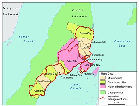
CEBU WATERSHED
Performance & PoNR Diagnostic
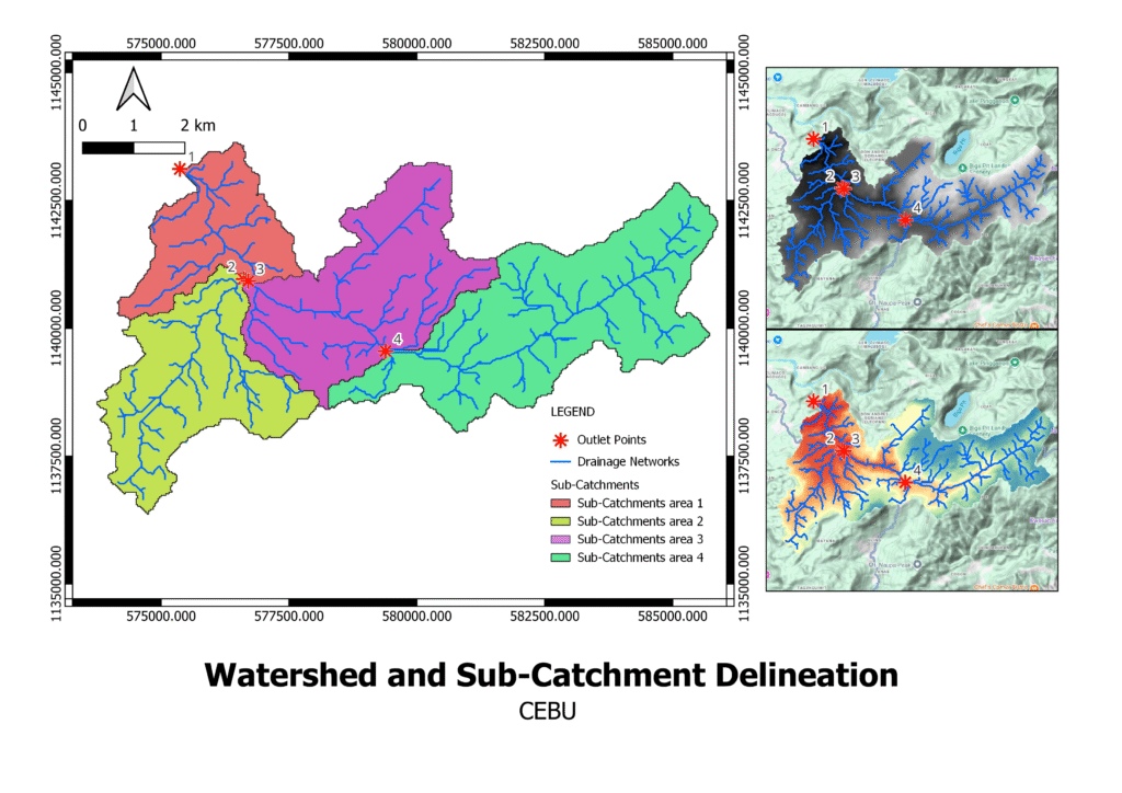
Executive Summary
The Cebu watershed is structurally functional but inherently high-energy due to its elongated basin geometry and confined axial valleys. TerrainX analysis shows that watershed behavior is governed not by downstream flooding areas, but by a narrow upper–central axial corridor where steep headwaters discharge directly into constrained valleys.
This corridor is approaching — and in places crossing — the Point of No Return (PoNR), where terrain-controlled processes become structurally irreversible regardless of downstream interventions.
TerrainX Performance Assessment
Basin Geometry (First-Order Control)
Cebu’s watershed exhibits:
- Elongated basin shape
- Laterally constrained valleys
- Axial (upstream-to-downstream) dominance
This geometry predisposes the basin to rapid runoff synchronization, limited storage, and minimal natural attenuation. This is a terrain reality, not a land-cover issue.
Sub-Catchment Performance Roles
🔴 Upper Headwaters — Trigger Zone
Steep slopes
Short flow paths
High relief concentration
Role: Trigger Zone
Controls onset and energy of peak flow.
🟠 Central Axial Corridor — Flow Compressor
Confined valleys
Rapid convergence
No lateral escape geometry
Role: Flow Compressor
Controls whether peak flow becomes irreversible.
🟢 Downstream Basin — Receiver
Gentler slopes
Wider valley sections
Role: Receiver
Inherits upstream energy but does not control system fate.
Performance Verdict
🟠 Classification:
Structurally functional but chronically high-energy and intervention-sensitive
Cebu does not fail because of “extreme rainfall.”
It fails because terrain geometry does not allow delay or dispersion once upstream thresholds are crossed.
Point of No Return (PoNR) — Cebu Watershed
What PoNR Means in TerrainX
The Point of No Return (PoNR) is reached when terrain structure becomes so committed to a failure mode that:
downstream mitigation cannot reverse behavior
restoration efforts become cosmetic
system response remains amplified even under reduced stress
PoNR Figure — Cebu Watershed (Annotated)
🔴 Red — PoNR-Crossed / Near-Crossing
Upper headwaters and upper–central axial corridor · Steep convex slopes feeding confined valleys · Incision and synchronization already locked-in
🟠 Orange — Last-Chance Zone
Central convergence areas · Still physically modifiable, but highly sensitive · Improper intervention here permanently commits basin behavior
🟢 Green — Receiver Zone
Downstream floodplain and outlets · Cannot fix upstream failure · Treating this zone alone guarantees repeat flooding
Cebu PoNR Field Checklist (15-Minute Verification)
Any engineer, LGU staff, or field team can verify these indicators quickly.
If 4 or more are observed in a red/orange zone → PoNR risk is real.
⬜ Steep headwater slopes draining directly into narrow valleys
⬜ Roads or cuts aligned parallel to flow paths in upper slopes
⬜ Channel incision deeper than bank vegetation root depth
⬜ Artificial drainage shortcuts bypassing natural meanders
⬜ Valley floors with no lateral floodplain width
⬜ Hardening (concrete, riprap) concentrated upstream
⬜ Repeated sediment removal at the same downstream locations
⬜ Flash flooding without rainfall increase
⬜ Landslides clustered upstream of flood zones
⬜ Downstream works increasing but less effective
⬜ Absence of natural storage along axial corridor
⬜ Reports of “sudden rise” flooding
What Cebu Teaches (TerrainX Insight)
Most interventions fail because they target where flooding appears, not where failure originates.
Cebu’s fate is decided upstream — not at the coast.
Downstream projects may reduce damage temporarily, but they cannot alter basin behavior once PoNR is crossed.
TerrainX Position (Clear & Grounded)
This assessment:
uses basin-scale DEM-based terrain diagnostics
establishes structural validity and PoNR risk
does not replace hydrologic or hydraulic modeling
Higher-resolution data (e.g., drone-based LiDAR) is appropriate only after PoNR zones are confirmed and prioritized.
One-Line Takeaway:
In Cebu, watershed failure is controlled by a narrow upper–central terrain corridor; once this zone crosses the Point of No Return, downstream flooding becomes structurally irreversible.
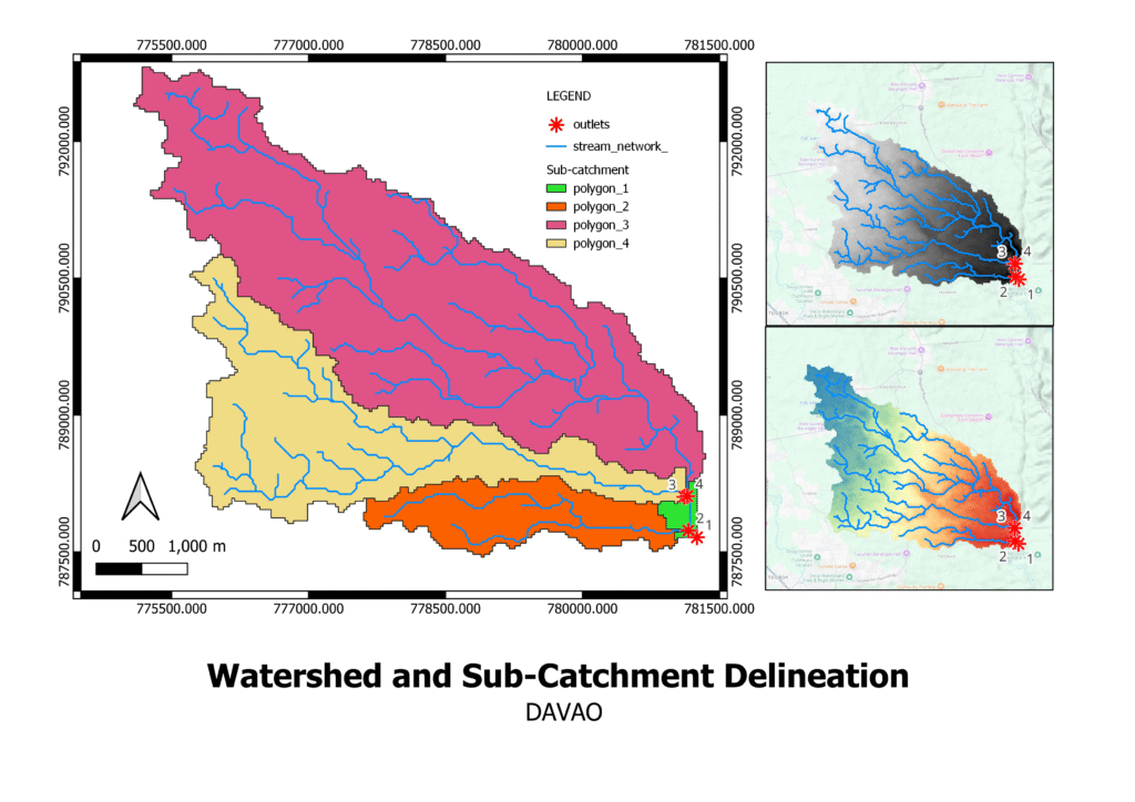
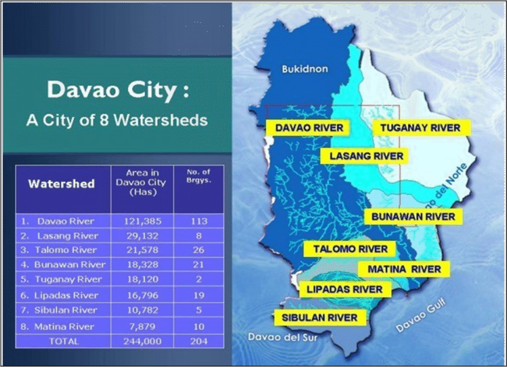
DAVAO WATERSHED
Performance & PoNR Diagnostic
Executive Summary
The Davao watershed is structurally functional with distributed resilience due to its multiple sub-catchments and outlets. Unlike elongated or single-axis basins, Davao’s terrain geometry allows partial energy dissipation through parallel drainage paths and broader valley sections.
TerrainX analysis indicates that system failure is not basin-wide but connector-sensitive — controlled by a limited number of terrain corridors that regulate how energy moves between sub-catchments.
TerrainX Performance Assessment
Basin Geometry (First-Order Control)
The Davao watershed exhibits:
Multiple contributing sub-catchments
Broader valley geometry
Reduced axial confinement compared to elongated basins
This geometry enables:
partial attenuation of peak flow
distributed storage
redundancy in drainage paths
The basin remains structurally functional — but not immune.
Sub-Catchment Performance Roles
🟢 Upper Interior Basin Sub-Catchments
Moderate slopes
Distributed drainage paths
Internal storage potential
Role: Volume Controller
Regulates how much water enters connector corridors.
🟠 Central Connector Valleys
Terrain corridors linking interior basins to downstream outlets
Narrowing valley sections
Flow acceleration zones
Role: Energy Modulators
Determine whether distributed flow becomes concentrated and damaging.
🟢 Coastal / Downstream Sub-Catchments
Wider floodplain geometry
Multiple outlets
Role: Receiver
Absorbs upstream behavior but does not control basin fate.
Performance Verdict
🟢 Classification:
Structurally functional with distributed resilience
Davao’s watershed still retains terrain flexibility, but this depends on maintaining integrity in central connector zones.
Davao does not fail easily — but it can be pushed into localized failure if key terrain links are compromised.
Point of No Return (PoNR) — Davao Watershed
What PoNR Means Here
In Davao, PoNR is not basin-wide like Cebu Watershed. It is localized and corridor-specific.
PoNR is crossed when:
connector valleys lose roughness
artificial drainage shortcuts appear
multiple sub-catchments synchronize unintentionally
Once this happens, localized flooding becomes persistent, even if other parts of the basin remain healthy.
PoNR Figure — Davao Watershed (Annotated)
🔴 Red — PoNR-Crossed / High-Risk Corridors
Central connector valleys showing confinement + incision
Early signs of synchronization
Small in area, large in consequence
🟠 Orange — Last-Chance Zones
Transitional sub-catchments
Still structurally modifiable
Misplaced infrastructure here locks in failure
Green — Receiver / Buffered Zones
Upper interior basin and coastal outlets
Currently functioning
Cannot compensate for upstream PoNR crossings
Davao PoNR Field Checklist (15-Minute Verification)
If 3–4 indicators appear in a red/orange zone, intervention urgency is high.
⬜ Valley narrowing between two contributing sub-catchments
⬜ Roads or drainage cuts parallel to natural flow in connector zones
⬜ Channel incision accelerating faster than vegetation recovery
⬜ Artificial drains bypassing natural floodplain sections
⬜ Concrete or riprap appearing upstream of urban areas
⬜ Sudden rise flooding reported without proportional rainfall increase
⬜ Sediment deposition shifting seaward year-to-year
⬜ Loss of small wetlands or overbank storage areas
⬜ Increased flood complaints localized to specific corridors
⬜ Multiple upstream areas now flooding simultaneously
⬜ Emergency works repeated in the same connector locations
What Davao Teaches (TerrainX Insight)
Davao demonstrates that multiple outlets and distributed geometry matter — but they are not guarantees.
Resilience is a terrain property that can be lost incrementally.
TerrainX Position (Clear & Grounded)
This assessment:
uses basin-scale USGS DEM-based terrain diagnostics
identifies distributed vs localized PoNR risk
does not replace hydrologic or hydraulic modeling
Higher-resolution data (e.g., drone-based LiDAR) becomes relevant after high-risk corridors are confirmed.
One-Line Takeaway:
Davao’s watershed remains structurally resilient, but localized connector corridors represent emerging Points of No Return if terrain integrity is not preserved. flooding becomes structurally irreversible.
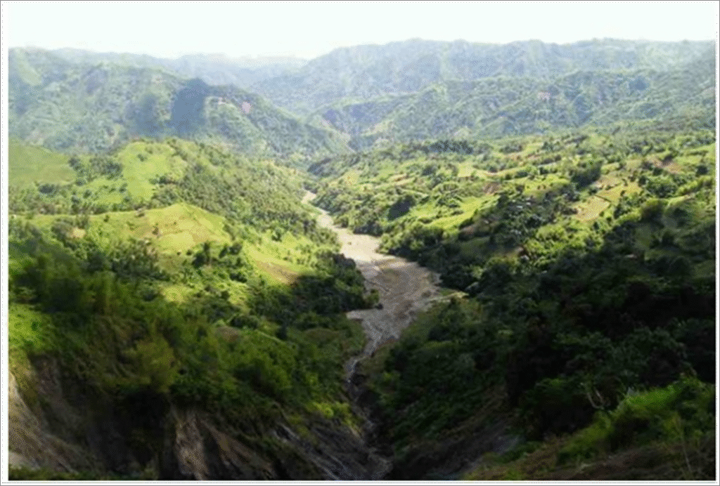
MASUNGI WATERSHED
Performance & PoNR Diagnostic
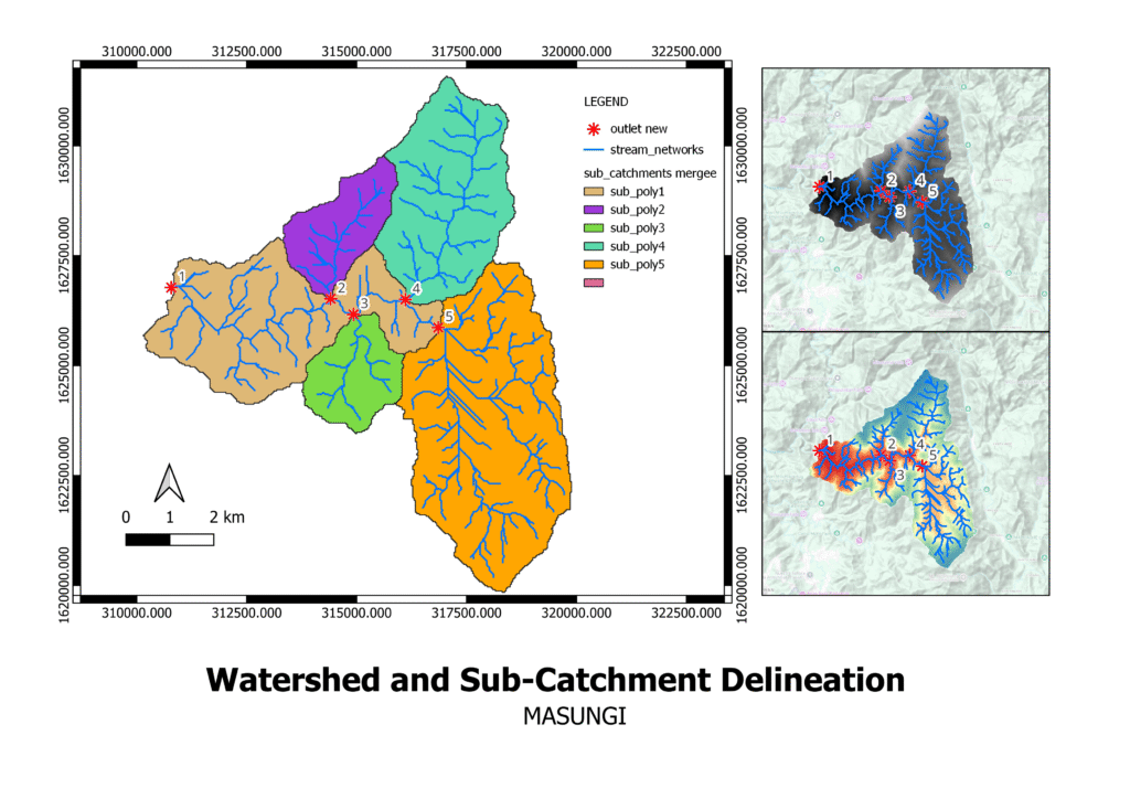
Executive Summary
The Masungi watershed remains structurally functional and geomorphologically coherent, but its performance is governed by a highly localized convergence zone. Unlike elongated or multi-outlet basins, Masungi’s terrain concentrates control into a single central junction, making the watershed stable but extremely sensitive to disturbance.
TerrainX analysis shows that Masungi has not crossed a basin-wide Point of No Return (PoNR). However, degradation within its central convergence zone would rapidly push the system into irreversible behavior despite intact forest cover elsewhere.
TerrainX Performance Assessment
Basin Geometry (First-Order Control)
Masungi exhibits:
Compact basin geometry
Strong ridge enclosure
Short internal flow paths
Single dominant convergence node
This geometry allows:
efficient internal drainage
limited natural storage
very high dependence on one control zone
Masungi does not fail gradually.
It fails suddenly if the wrong location is compromised.
Sub-Catchment Performance Roles
🟢 Peripheral Sub-Catchments (Outer Slopes)
Moderate slopes
Short tributaries
Forested surfaces
Role: Support & Feed
These areas contribute flow but do not control basin behavior.
🔴 Central Convergence Zone
Multiple tributaries meeting at low relief
Limited valley width
No alternative dispersal path
Role: System Governor
This zone controls:
peak synchronization
erosion amplification
downstream response
If this node fails, the entire basin shifts behavior instantly.
Performance Verdict
🟠 Classification:
Structurally intact but convergence-sensitive
Masungi remains healthy only because its central convergence zone is still intact.
Forest cover alone does not guarantee safety — terrain structure does.
Point of No Return (PoNR) — Masungi Watershed
What PoNR Means in Masungi
In Masungi, PoNR is:
highly localized
node-controlled
binary (intact vs failed)
Once the convergence node is degraded:
erosion accelerates immediately
peak discharge shape becomes irreversible
downstream damage persists regardless of restoration elsewhere
PoNR Figure — Masungi Watershed (Annotated)
🔴 Red — PoNR Control Node
Central convergence zone
Multiple tributaries meeting
Any disturbance here commits basin behavio
🟠 Orange — Last-Chance Support Zones
Immediate upstream contributors
Still modifiable
Mismanagement accelerates node failure
🟢 Green — Peripheral Contributors
Outer sub-catchments
Structurally stable
Cannot compensate for node collaps
Masungi PoNR Field Checklist (15-Minute Verification)
If 2–3 indicators appear in the red zone → PoNR risk becomes immediate.
⬜ Road cuts or trails crossing the convergence zone
⬜ Drainage ditches redirecting tributaries unnaturally
⬜ Channel incision deeper than surrounding root depth
⬜ Loss of lateral roughness at the confluence
⬜ Concrete or riprap introduced near the node
⬜ Sediment bars forming suddenly at downstream outlet
⬜ Flash runoff observed despite stable rainfall patterns
⬜ Small landslides clustered near tributary junctions
⬜ Artificial narrowing of the valley floor
⬜ Repeated maintenance at the same confluence location
What Masungi Teaches (TerrainX Insight)
Masungi demonstrates a critical TerrainX principle:
Some watersheds fail not because they are degraded everywhere, but because they depend on one irreplaceable terrain node.
Protecting Masungi means:
absolute protection of the convergence zone
zero tolerance for disturbance at that node
disciplined land-use control upstream
TerrainX Position (Clear & Grounded)
This assessment:
uses basin-scale DEM-based terrain diagnostics
identifies node-controlled PoNR risk
does not replace hydrologic or hydraulic modeling
Higher-resolution data (e.g., drone-based LiDAR) is appropriate only if the convergence node is threatened or contested.
One-Line Takeaway:
Masungi remains structurally intact, but its watershed performance depends entirely on a single convergence zone whose failure would trigger irreversible behavior.