Geospatial Imagery, Processed into Actionable Information
Upload your imagery or geospatial dataset. AppliedSpatial examines, processes and converts it into reliable GIS-ready products and analytical outputs
GeoComms AppliedSpatial Ecosystem
From Spatial Data to Verified Field Action
An integrated workflow connecting drone imagery, GIS analysis, RTK positioning, QField field validation, and reporting to turn spatial data into practical, field-ready information.
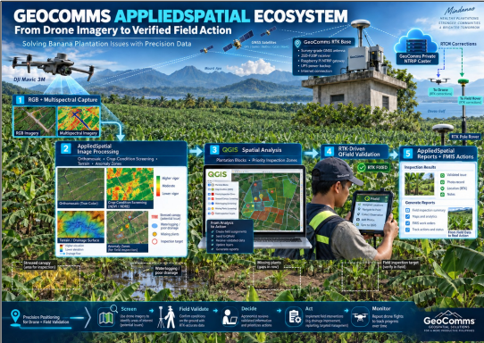
GeoComms AppliedSpatial Ecosystem
From Drone Imagery to Verified Field Action
RGB + Multispectral Capture
Geotagged drone photography and multispectral sensor data collected over the survey area using DJI Mavic 3M and compatible platforms.
AppliedSpatial Image Processing
Secure upload, quarantine inspection, dataset examination, photogrammetric or geospatial processing, and quality review.
QGIS Spatial Analysis
Processed outputs are analyzed in QGIS for plantation block delineation, vegetation indices, anomaly zones and management zone classification.
RTK-Driven QField Validation
Field teams are guided by QField to priority inspection zones identified from aerial analysis. RTK-accurate positions, photos and observations are collected.
AppliedSpatial Reporting + FMIS + Actions
Validated results are compiled into technical and analytical reports. Data flows into FMIS for work orders, intervention plans and operational records.
Supported Inputs
- Geotagged RGB drone photographs
- Multispectral drone imagery
- Thermal imagery
- Satellite imagery
- Georeferenced LAS/LAZ point clouds
- Existing orthomosaics and elevation models
Processing Outputs
- Orthomosaics
- Digital surface models
- Digital terrain models
- Point clouds
- Textured 3D models
- Contours and measurements
- Vegetation indices
- Classified management zones
- Change-detection maps
- GIS-ready GeoTIFFs and vectors
- Technical and analytical reports
Processing Workflow
Security-First Data Pipeline
Every submitted dataset undergoes security inspection and technical preflight examination before entering the processing environment.
Secure Upload
02
Quarantine
Dataset Examination
Processing
Quality Review
Analysis
Delivery
Processing Workflow
Choose the Level That Fits Your Decision
Every submitted dataset undergoes security inspection and technical preflight examination before entering the processing environment.
Processing Outputs
Standard photogrammetric or geospatial products.
Mapping and Analysis
Processed outputs with measurements and interpreted zones.
Field-Validated Assessment
Analysis strengthened through QField inspection.
Monitoring Program
Repeat observation and change measurement.