RTK Field Tools → RTK Network
Centimetre-Level Positioning, Connected to Your Field Operations
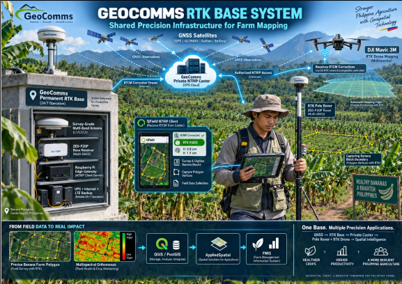
GeoComms RTK Network delivers real-time GNSS correction data through a private NTRIP infrastructure, connecting RTK rovers, drones, QField, QGIS and FMIS for precise field positioning.
RTK Correction Workflow
GNSS Satellites
GeoComms RTK Base
RTCM Corrections
Private NTRIP Caster
RTK Rover / Drone
QField · QGIS · FMIS
System Architecture
One correction infrastructure. Multiple field users.
A nearby RTK rover combines the correction stream with its own satellite observations to achieve centimetre-level positioning under suitable field conditions.
Permanent Reference
A stable, survey-grade antenna and fixed reference station provide a consistent local positioning source.
Private Corrections
RTCM 3.x correction data is distributed through a secured GeoComms private NTRIP caster.
Shared Infrastructure
The station can support multiple authorized rovers, drones, universities, plantation teams and provincial partners.
Technical Specifications
Production-oriented RTK infrastructure.
The following represents the GeoComms production specification or a validated equivalent where applicable.
| Component | GeoComms Production Specification |
|---|---|
|
GNSS receiver |
u-blox ZED-F20P triple-band RTK receiver, or validated equivalent |
|
Frequencies |
L1, L2 and L5 |
|
Constellations |
GPS, Galileo, BeiDou, QZSS and NavIC |
|
Positioning modes |
Stationary RTK base; survey-in or fixed-coordinate mode |
|
Correction format |
RTCM 3.x, including reference-station and multi-signal observation messages |
|
Antenna |
Survey-grade, triple-band calibrated GNSS antenna |
|
Antenna installation |
Permanent monument, stable mounting, clear sky view and measured antenna height |
|
Edge controller |
Raspberry Pi or industrial Linux gateway |
|
Communication |
Ethernet preferred; Wi-Fi or 4G/LTE backup |
|
Distribution |
GeoComms private NTRIP caster hosted on a secured VPS |
|
Power |
Regulated supply with UPS; optional solar and battery backup |
|
Monitoring |
Station connectivity, RTCM flow, satellite status, latency, uptime and client sessions |
|
Security |
Individual accounts, protected mountpoints, TLS where supported, access logs and account suspension controls |
|
Rover output |
RTK Float or RTK Fixed status delivered to QField, GIS, drone or other field system |
Performance
Expected Performance
Target rover accuracy:
Centimetre-level horizontal positioning after achieving RTK Fixed.
Recommended operational radius:
Approximately 20–30 km for dependable local work.
xtended operation:
Potentially up to 50 km in open environments, but fixing time and reliability may deteriorate with distance and atmospheric differences.
Requirements:
Compatible rover, continuous correction stream, suitable antenna, open sky, stable internet and correctly established base coordinates.
Limitations:
Trees, buildings, multipath, radio interference, mobile-data interruptions and incorrect base coordinates can materially reduce accuracy.
Applications
GeoComms Applications
Farm polygon tracing:
Create more precise plantation blocks, management zones and asset locations using an RTK pole connected to QField.
Precision agriculture:
Geolocate crop anomalies detected through multispectral imagery and return to the same inspection point.
Drone operations:
Provide compatible RTK drones with local corrections for repeatable mapping and improved image georeferencing.
FMIS integration:
FMIS integration:
Locate roads, irrigation lines, drainage structures, utilities and plantation facilities.
Education and research:
Provincial partner network:
Host partner-operated reference stations while GeoComms manages caster access, monitoring, standards and system integration.
Positioning statement
GeoComms RTK Base provides the positioning backbone connecting drones, RTK field instruments, QField, QGIS and FMIS—turning
centimetre-level locations into verified and actionable operational records.